

Trekking was the centre piece of our trip to Iceland. In the very early planning stages it was the big bean that tipped the scales in the favour of visiting Iceland (in this scenario the scale has dozens of arms, with a potential destination hanging off of each end begging to be explored).
There are several places you can do guided multi-day hikes in Iceland and after a lot of deliberation I finally decided on the six day Laugavegur trek from Landmannalaugar to Thorsmork and around the Fimmvorduhals. There were some very tempting looking treks in the Skaftafell area, but the deciding factor was that the Laugavegur trek is famed for offering some of the most diverse landscapes in Iceland. As you move through the trek the out of this world vistas change from day to day.
The planning and equipment logistics as well as the local knowledge made the decision to participate in a guided trek (rather than go it alone) a no brainer. And this decision was well justified in terms of safety, companionship of the group and the wealth of information our guide was able to share with us about the trail and Iceland in general. The trail is well established and would be easily navigable on your own with a good map and compass for support but there are risks. On our first day of our trek a man (not associated with our trek) fell through an unstable ice bridge and died in the area we were walking through.
All of the organised treks through this area are assisted, which means that you only walk with a day pack. Your large bags, the kitchen tent and daily food supplies are transported between the campsites each day. Again, from a logistics point of view this was fantastic for us as we are travelling as part of a three month trip and would have had to arrange storage for all of our none hiking essentials in Reykjavik to get our big bags down to a manageable trekking weight. It obviously also makes the walking much more comfortable.
It has been quite difficult to try and find the words to describe this trek in terms of my own experience and feelings. It was absolutely magnificent and I know that it is one of those experiences that will have a long lasting impact.
Day one – Landmannalaugar to Hrafntinnusker
The trek group met in Reykjavik. The company we were walking with had two groups going who would be staying in tents and one group who would do the trail and stay in the permanent huts. The drive out to the start of the trek takes about 2 1/1 hours to Landamannalaugar. After about an hour and a half, the bus turns off the road and begins the most incredible ascent through black sand. The super bus then begins to climb through an incredible peaked area and takes on terrain you would be impressed to traverse in a normal 4WD.
As you approach Landmannalaugar you begin to see the iconic striped hills that are streaked with yellows and reds. The drop off point is at the bustling campsite. For those spending longer there, there is the opportunity to brave the icy air temperature and take a dip in the thermally heated natural stream.
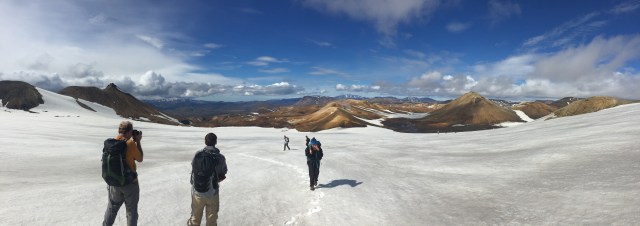
You will hear many times from guides and hikers that this trek was listed as one of the top twenty treks in the world by National Geographic a few years ago and it is immediately easy to see why it received an entry on the list. You leave Landmannalaugar through the lava field of Laugahraun (believed to have been formed in 1477). This is followed by a steep ascent of about 500 metres which offers spectacular views back through the delta of Landmannalaugar.
As you continue to climb you can see the volcano, Hekla, off in the distance. The pressure has been building up in Hekla and an eruption is overdue. This season all climbing trips to the mountain have been cancelled in anticipation of some imminent activity.
In the other direction you can see the colossal Vatnajokull, the glacier that dominates the south east corner of the country. You soon descend into the Storhiver area which is the first chance to see the mind boggling meeting of hot and cold. Steaming hot streams pour out from under giant slabs of ice – the icy valley is filled with streams hot enough to make a cup of tea over. After several snow crossings you finally come to the top of a big hill to look down into the Hrafntinnusker area and the first campsite.
Day two – Hrafntinnusker to Alftavatn
After a morning of intermittent fog, our group set off at about 10 am. We had set a quick pace the day before so the delayed start meant that we had the track to ourselves. Hrafntinnusker means obsidian skerry which is very fitting as you are walking through rolling black hills. For us these obsidian crossings were spectacularly cut with sections of snow.
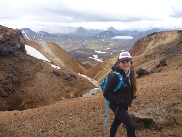
After a steep climb out of the valley, we were offered the chance to take a ‘short’ (2- 3 hour) detour. This took us through an impressive black delta valley and to the foot of a glacier. From there we climbed the steep snow to the top of Haskerdingur which, at 1281 metres, is the tallest peak in the area. This offered even greater views of the surrounds as well as the distinctive Hekla and Vatnajokull.
The snow allowed us to run or slide down the mountain much quicker than we had ascended. After exiting the canyon past some impressive bubbling mud pots and steaming outlets we rejoined the main trail. You are faced with some quite steep descents for the second half of this day and several sections of shoaly path which require a slow and inelegant shuffle that makes your knees decidedly unhappy. When you are not looking for a safe place to plant your feet you are treated to incredible views down to Alftavatn or Whooper Swan Lake.
A change in the weather gave us the opportunity to try out our wet weather gear for the last few kilometres. The last section is an easy flat walk so this didn’t pose too many dramas and arriving a little cool and very damp to the campsite meant that camp dinner tasted twice as good. This campsite is situated on the very edge of a picturesque lake.
Day three – Alftavatn to Emstrur
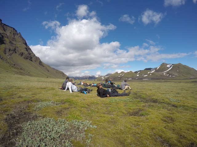
From Alftavatn you hike east over a couple of small hills toward Hvanngil. There is a river crossing early on. It was fairly straight forward while we were there but the water was painfully cold. You trek through beautiful green fields and rolling hills for a short stretch before the lush fields begin to give way to a long flat plain of black desert.
The second river crossing is a little wider and more demanding but again we were quite fortunate that the volume of water was relatively low on the day. From here the hike is mostly through the wide black desert sands of Maelifellssander. Our group was once again offered a detour to take a closer look at the glacier Myrdalsjokull which is a dominant and ever present companion on the horizon throughout the duration of the trek. This walk took us to one of the most beautiful places I have ever seen in my life. We celebrated this find by taking a short nap in the sun before hitting the trail again.
The arrival at Emstrur was dusty and very warm. The 500 kronor (over $5 AUD) for a five minute shower felt like money well spent at the end of such a big, dusty day.

Day four – Emstrur to Thorsmork
The track out of Emstrur delivers several kilometres of small hills, none of which are too demanding. You cross an impressive river by bridge early in the day and soon after this you are able to take a detour that is short by conventional standards, (5-10 minutes rather than the 2-3 hours diversions we had become accustomed to), to view the juncture of two different coloured rivers.
After a few hours you are treated to the rare sight of small scrub and birch trees along the path. I heard a joke on our travels: What do you do if you get lost in a forest in Iceland? Stand up. Not only are trees an infrequent occurrence but typically they are quite small and sparse.
A final river crossing takes you across many small streams on a wide delta. In relative terms these streams seemed much warmer than the previous crossings. The relative temperature of the water depends on whether it comes directly from glacial run off. One more wide hill crossing takes you into the valley side campsite at the gorgeous Thorsmork. The Thorsmork area is a long stone river bed flanked by high dark peaks along each side. There are several campsites in the area and it is used as a launching point for many trails.
Day five – The Fimmvorduhals
This day had been dwelling in most people’s minds as the toughest day of walking as the track is straight up a big mountain (and return). A few people selected to stay in camp and explore the local area at their own pace or relax as we would be spending the final night in Thorsmork again. Although it was a continuous climb I thought the track was much easier than the preceding days as the trail itself was well developed and it cut back and forth across the face of the mountain at a very comfortable gradient.
My feet were in a very sorry way (more on that shortly) so I had been worried that I would not be able to get shoes on let alone hike but I decided to walk out to the trail head to see how I went. As it turned out I went 14 kilometres all up and made it to the top of the mountain ridge for breathtaking views of one of Myrdaljokull’s powerful icy walls and captivating 360 degree view (you don’t get sick of them).
I continued down by myself so I could take my time on my tender toes while Ryan and the rest of the group continued along the ridge to battle very fierce winds for a close up look at two of Iceland’s newest volcanic craters, Magni and Modi.
Day six – Thorsmork and return to Reykjavik
The final day was a short trip out of camp to a nearby canyon before packing up and preparing to return to Reykjavik. Packing the bus was a feat for Tetris Grand Masters but eventually we were all stowed and on our way back to the city for a celebratory beer or six.
One of the deal breakers for an experience like this can be the people you end up spending the week with and we couldn’t have been more fortunate with our group. Not only were they all fit and proficient walkers, they were really interesting and lovely people. Our guide was a fascinating person and shared so many interesting stories and pieces of information about Iceland and the environment we were walking through. I really couldn’t recommend this experience highly enough. The walk is quite challenging and the fitter you are the more you will enjoy it.
My sad feet
Bec: Hey there my friend, how are you going?
Ryan: Good thanks.
Bec: Not you, I was talking to my blister.
I could write an entire essay on the sad state of my feet and hypothesise about what went wrong but the relatively short version is that despite good shoes and socks, a fairly robust breaking-in period and early use of taping and second skin, my feet were an unhappy mess.
Before we even arrived in Iceland I was confident that I was going to finish the trek sans a toe nail (from breaking the shoes in). Nail issues horrify me but I was adopting a stoic determination to strap it up and pretend it wasn’t happening for a week.
On the third day we stopped for a second lunch and I removed my shoe to find a tiny piece of gravel had created a minuscule blister on the outside of my right heel. I taped that tiny bad boy up confident that it would be nothing more than a minor irritation. That evening we arrived in camp and boom! Blister city. Each heal had developed monster sized eruptions on the outside (which, given their volcanic proportions I have since christened after two local volcanoes, Katla and Hekla).
In keeping with the geothermal theme, I had also developed a swag of blisters that resembled a field of bubbling, dangerous geothermal outlets around my toes. I second skinned and strapped as best I could (a risky move as I am very allergic to the glue in tape) but Hekla on my left heel continued to grow and grow over the next few days to the extent that I was concerned that I might have been sprouting a second foot. Fortunately Katla erupted of her own accord sometime on the fourth day so despite some short lived intense pain and a decent amount of icky, this offered some relief overall.
Anyway, that is enough about my festy feet. The days following the hike were spent in the blissful respite of thongs (flip flops for non-Australian readers, I am not over sharing about my underwear). This gained more than a few odd looks and comments from tourists who were all trussed up in their best hiking gear to explore sites that required a taxing walk down 400 metres of gravel path. I waved the still-in-full-bloom Hekla in their general direction which soon scared them away.
Tent or hut?
I would recommend the tent option. The huts are typical shared hiking huts (not personal cabins) and are pretty bustling and manic at some of the places. Although it is a little bit trickier in tents if the weather is wet, the tent gives you your own small but private space to unwind in at night and you can go to bed or get up whenever suits without disrupting or being disrupted too much. Want to have a ‘bird bath’ with wet wipes because there are no showers? Much easier in the privacy of your own tent.
The atmosphere in the group dining tent is also quite nice as everyone pitches in to help prepare meals or just sits and swaps stories while they relax with a cup of tea. Another consideration is that I get the impression that the tent group tends to attract slightly more active and fitter people than the hut group (but overall most people I met seemed quite experienced and were up for the challenge regardless of which option they had selected).
Do it yourself
The company we used was adventures.is . We booked through icelandroadtrip.com because they required a smaller deposit which allowed us to book and secure our dates earlier.
